
Assegaaiboschkloof looking east on a clear day
The mountain club’s plan was to walk from Franschhoek to Jonkershoek along the watershed via Emerald Dome and Victoria Peak. We would ascend Fortsnek and cross Noordkloofpiek, the scene of last year’s firefighting. It promised to be a long, hard, but spectacular, day. But an unseasonal south-easter raged through the night and clouded in the peaks, so we decided to follow the upper Berg River above the dam, up Assegaaiboschkloof to Bergriviersnek. The path has been recently maintained and is in excellent condition, except for the lower section which scramblers have obviously been using. A Google Earth track and photos follow …
Map of Assegaaibosch route. Alternatively, download the kmz file and view in Google Earth.

Assegaaiboschkloof – view towards Bergriviersnek
As we breasted Bergriviersnek, we spotted smoke beyond the next range, obviously on the Helderberg. Within minutes it became a massive, mushrooming cloud. Soon the fire alert pinged on our ‘phones, scrambling the VWS standby crew. That fire would raze a number of houses and a hotel on Helderberg’s slopes.
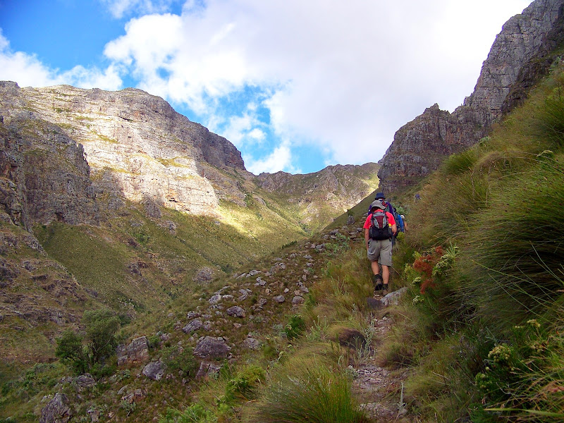
Approaching Bergriviersnek
Discover more from Ralph Pina
Subscribe to get the latest posts sent to your email.
Our hiking group is planning to do this hike from Jonkershoek, starting the ascent along the Panorama Route to the Bergriviernek, and then down the Assegaaiboschkloof to Franschoek. Considering your group did this hike in reverse very recently, is there anything we need to know about the descent through the valley, before we embark on this hike? The Jonkershoek office claim that this is not an “official” hiking trail, and cannot give me much information on it, although Google Earth indicates quite a clear route. My concern is, that at the bottom of the Nek, the path heads into a forested area, and I cannot discern what the terrain is like through this section of the valley. Any advice or information you can give me about the route will be much appreciated. Regards, Fran
Hi Fran
The route is very clear and well maintained. There is no problem in following the trail. The descent down from the nek is fairly steep but the path zigzags down and after that it’s fairly easy walking.
hope that helps.
Hi Ralph
We eventually got to do this route on Saturday, as we’ve had to postpone it three times due to bad weather conditions. It was well worth the wait as we could not have asked for more perfect conditions on the day! We were simply overwhelmed by the spectacular scenery, and being dwarfed by the magnificent towers of rock on either side of us.The zigzags down made the task of the descent quite do-able, although there were some slippery grassy patches.The pool at the bottom of the descent was a piece of paradise, and the rest of the route easy and beautiful. The benefit of doing the route this way was that we were spoilt with constant vista of the kloof ahead of us. Incredible hike!! The only element that spoilt it was an encounter with scramblers using the hiking path for about 2km’s up … pity. Anyway, just wanted to thank you for your input, and for the GE track, which helped tremendously in planning the hike.
Rgs
Fran
Hi Ralph
I am planning to do this hike from the Jonkershoek side to Franschoek over the coming long weekend (23/24 Sept 2012). Have children with me – youngest is 10. Can you help me with a bit more info….
Do you think it is suitable for Children that age?
Is it possible to free-camp overnight to break the hike and make it more of an “adventure” for the kids?
Which route would you recommend as there seem to be a few options?
Are there any trail maps / guides available for the routes.
Thanks
Jeff
Hi Jeff
Unless the child is used to hikes and is strong, this one may be a bit long and hard for a single day.
CapeNature does not allow free camping in the reserve, so that’s not an option.
I would recommend doing the various day hikes in Jonkershoek or if you want to do an overnighter, perhaps a section of the Boland Trail from Nuweberg to Jonkershoek with an overnight at Landdroskop. The latter is also a fairly serious hike however.
I would also recommend the short Palmiet and Leopard’s Gorge walks in the Kogelberg, where you can overnight at the new eco-cabins. This may be the very best option for children in my opinion.
CapeNature provides reasonable trail pamphlets, so I would suggest contacting them. There used to be a good Boland Trail map, which showed many of the trails and routes in the area, but I am not sure where one gets this anymore. Suggest you contact CapeNature at http://www.capenature.co.za.
regards
Ralph
Hi Ralph
I am planning on doing the hike with a group of friends this coming weekend, and was wondering if there is place to park ones car on the Franschhoek side (specifically at the starting point as on the gps track above) and further, if there are any locked gates on the way to the starting point.
Regards
Peter
Hi Peter, The tarred Robberstvlei road ends at the entrance to the dam area. These gates are locked. You can park there, but would have to accept the risk and lack of shade. I believe that one could perhaps obtain permits to enter the area by vehicle from Water Affairs, but I am not sure.
Thank you Ralph. I will contact Water Affairs to see if I can obtain a permit. I think 22km plus the extra 5km to the tar road may be a bit much for me for one day!
Peter any feedback on how you handled the parking on the Franschoek end , and generally how was the hike
We hiked it this past Saturday (3rd) . The trail was a little overgrown coming down Bergriviernek into Assegaaiboskloof, but still easy to follow. It was raining throughout the day, so needless to say we were very cold and wet, yet it was still very enjoyable. We ended up parking at the end of the Robertsvlei road ( 33°56’2.34″S 19° 4’58.10″E) and there were other cars there as well. The gate admitting entrance to the dam was not locked so perhaps one could park a little closer. The total trip length from the Jonkershoek station to where our cars were parked totalled 26km, but the terrain was easy enough such that we weren’t stressed for time at all.
Concur with your comments Peter , we did the hike on Sunday 4/10/2015 . We had fog , rain and hot sun. A beautiful hike but be prepared and wear long pants .Started at ‘wit brug’ at 9:00am and met our transport at 17:30 at the Robertsvlei end .Our driver had parked ‘ a little bit closer’ and saved us about 5 KM. Thanks Ralph for bringing a great hike to our attention.
Good morning fellow hikers,
I trust everyone is doing great. We would like to hear if anyone has done this hike from Jonkershoek via the waterfall trails? I see that there are trails leading up to waterfall 2 and beyond that meets up at the view point as well before going down to Franschhoek.
Would love to hear what you think of that.
Kind regards